


Autour de Fontjulien (Rando Santé)

denis48230
User
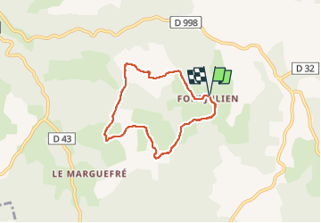

Length
6.1 km

Max alt
901 m

Uphill gradient
166 m
Km-Effort
8.3 km

Min alt
814 m

Downhill gradient
167 m
Boucle
Yes
Creation date :
2024-12-29 12:30:11.82
Updated on :
2024-12-29 14:25:42.644
1h55
Difficulty : Medium

FREE GPS app for hiking
 SityTrail
IGN / Geographical institutes
SityTrail Plus
The world is yours!
About
Trail Walking of 6.1 km to be discovered at Occitania, Lozère, La Canourgue. This trail is proposed by denis48230.
Positioning
Country:
France
Region :
Occitania
Department/Province :
Lozère
Municipality :
La Canourgue
Location:
La Capelle
Start:(Dec)
Start:(UTM)
522070 ; 4916375 (31T) N.
Comments